Record temperature swings damaged apple orchards, wine grapes, blueberries, and citrus across the eastern U.S. this season. Here's how asset-level weather data changes the outcome next time.
The woes of frost season discussed in the previous article are not isolated to California. Just as a shifting climate is altering the bloom cycles of California almonds, it is creating a volatile environment for fruit orchards across the eastern United States. Farms and orchards native to the east coast saw similar hazards associated with chaotic weather patterns this past April, including late season frost.
The impact of a spring freeze isn't uniform; different crops face unique physiological hurdles depending on how they break dormancy and begin to bloom or bud. Some crops like strawberries were able to escape the harsh season with lesser setbacks while other crops saw similar stories to vineyards and almond orchards in California.
The eastern crops at risk
Apples
Apples are an economically vital crop for states like New York, Pennsylvania, and Virginia. While apple buds are hardy during the winter, their frost tolerance drops drastically as they progress through the green tip and pink bud stages. A late-spring freeze can kill the flower's pistil, preventing fruit development entirely or causing a scarred, "frost ring" on surviving fruit.
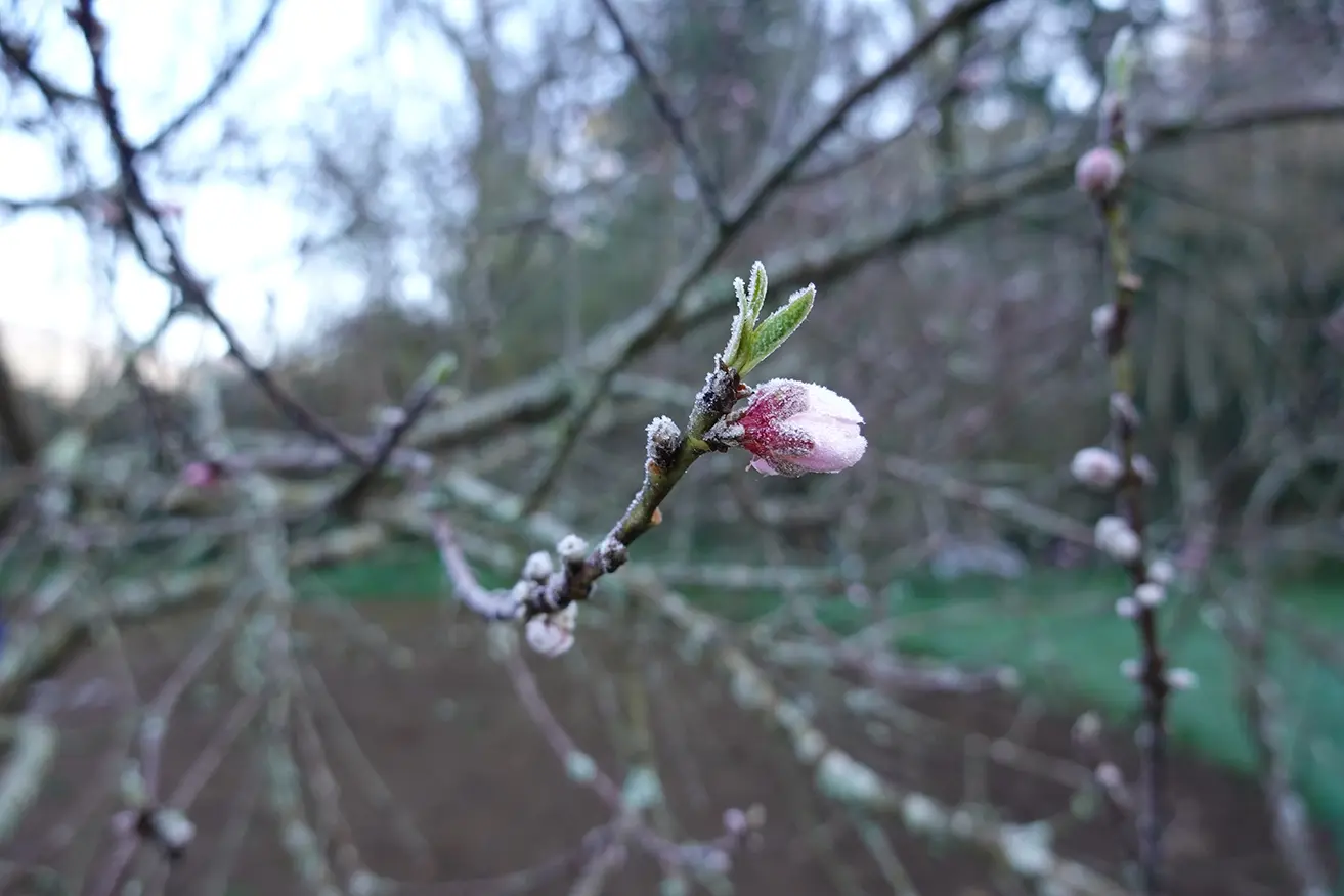
Peaches
As stone fruits, peaches are notoriously high-risk because they have lower chill hour requirements than apples, causing them to bloom much earlier. This early awakening means peach blossoms are easily susceptible to the chaotic shifting patterns that spring brings.
Cranberries
Primarily grown in Massachusetts and New Jersey, cranberries face severe radiation frost risks. Because cold air is heavy, it drains into these low bogs on calm nights, making the temperature significantly lower than the surrounding hillsides.
Blueberries
A major crop across New Jersey, Michigan, and the Carolinas, blueberries are highly vulnerable at the pink bud stage. This window is arriving earlier each year as warm, late-winter temperatures accelerate development. Losses from the April event were significant across mid-Atlantic growing regions.
Wine Grapes
In New York, the Finger Lakes vineyards and Virginia's growing wine country face risks that mirror those in California's Central Valley. Bud break is the most vulnerable moment, and the same weather whiplash pattern that devastated western vineyards played out similarly across eastern states this spring.
Citrus
Citrus faces a different version of the same threat. In late January 2026, a bomb cyclone funneled arctic air deep into Florida, with snow and ice across the Appalachians keeping the airmass cold well into the peninsula. Jacksonville hit 22°F and Orlando dropped to 24°F, both daily records, with key citrus-growing areas sustaining temperatures below 28°F for more than four hours. Growers ran overhead irrigation systems through the night, using the latent heat released as water freezes to hold tissue temperatures near 32°F. Trees already weakened by citrus greening disease were hit hardest, their thinner canopies providing less insulation against the cold.
Critical temperature thresholds by crop and growth stage
Understanding when frost becomes damaging is as important as the forecast itself. The table below reflects commonly cited kill temperatures for eastern crops at their most vulnerable bloom stages:
| Crop |
Vulnerable Stage |
10% Kill Temp |
90% Kill Temp |
| Apple |
Pink bud (first pink) |
28°F (-2°C) |
24°F (-4°C) |
| Apple |
Full bloom |
28°F (-2°C) |
25°F (-4°C) |
| Peach |
Full bloom |
27°F (-3°C) |
24°F (-4°C) |
| Blueberry |
Pink bud |
23-25°F (-5 to -4°C) |
Below 23°F |
| Wine grape |
Budbreak |
~30°F (-1°C) |
— |
| Cranberry |
Early bud |
~30°F (-1°C) |
— |
| Orange |
Fruit on tree |
28°F (-2°C) for 4+ hrs |
— |
| Grapefruit |
Fruit on tree |
26-28°F (-3 to -2°C) |
— |
| Mandarin / Satsuma |
Fruit on tree |
24°F (-4°C) brief |
— |
Sources: Penn State Extension (adapted from WSU EB0913, EB0914); MSU Extension; UC Cooperative Extension; UF/IFAS 2025–2026 Florida Citrus Production Guide; UMass Cranberry Station / University of Maine Cooperative Extension (C.J. DeMoranville, revised 2019). Apple and peach thresholds reflect 30-minute exposure. Citrus thresholds reflect 4+ hour exposure. Wine grape and cranberry 90% kill thresholds vary widely by variety; ranges not listed.
The meteorological setup
As was the case with the pattern over the West Coast, the hazardous weather was brought upon by a multi-stage event starting with an anomalous warm spell. Plants were experiencing subtropical highs in the 90s when a strong cold front riding an unstable jet stream abruptly returned the polar vortex to the region. As a large cooler airmass was dragged in behind the exiting front, many locations saw extensive frost, especially in the deep valleys and bogs where many crops are situated.

What growers can do
Frost protection isn’t a passive enterprise, and it's only as effective as the forecast behind it. A county-level forecast won't tell a Virginia peach grower that their low-lying blocks are running 4°F colder than the ridge above them.
WWG's weather stations, equipped with temperature and relative humidity sensors, capture that variance, the microclimatic detail that determines whether a crop survives a marginal frost event. That site-specific intelligence is the foundation for every protection decision a grower makes.
-
Wind machines and helicopters mix warmer air aloft with cold surface air during radiation frost events. Activating them too early wastes fuel; too late and the damage is done. WWG's asset-level temperature sensors and short-range forecasts give operators the precise timing they need.
-
Overhead irrigation for frost protection coats buds and blossoms in a thin layer of ice, releasing latent heat and holding tissue temperature near 32°F even as ambient temps fall lower. WWG's real-time sensor data and alert thresholds keep growers informed through the entire event, not just at the start.
-
Row covers and frost blankets provide passive insulation for low-growing crops and vulnerable young vines. WWG's hyperlocal forecasts, built from on-site sensor data rather than regional airport readings, give growers the confidence to deploy at the right moment.
-
Pre-irrigation before a cold night moistens the soil surface, increasing its heat capacity and slowing the nighttime temperature drop at crop level. The same principle used by Florida citrus growers running water through deep freeze events applies here: wet soil releases heat more slowly than dry soil, providing a thermal buffer that can mean the difference of a degree or two when crops are on the threshold. WWG's site-specific temperature forecasts and sensor alerts give growers the advance notice needed to pre-irrigate at the right time, not after the window has closed.
Shifting climate
What happened this spring wasn't a fluke. The same volatile spring patterns reshaping bloom calendars in California's Central Valley are rewriting the rules for growers from the Florida panhandle to the Finger Lakes. Warm late-winter stretches are arriving earlier, pushing crops out of dormancy weeks ahead of schedule, and then the bottom drops out. Studies show long-term increases in springtime temperature swings across the eastern U.S., and 2026 is far from the first warning. A similar heat-freeze collision in 2017 wiped out significant fruit crops across the region. The pattern isn’t an anomaly, it's a trend.
Growing degree day accumulation is accelerating, traditional bloom windows are shifting, and the forecasting tools growers relied on for decades such as regional models, county-level alerts, and airport weather stations miles from the field, were built for a climate that no longer exists.
WWG's approach starts at the asset level. Our weather stations capture the microclimatic variance that determines whether a low-lying peach block freezes while the ridge above it doesn't. The kind of one- to four-degree difference that separates a marginal frost event from a lost crop. That ground-truth data, combined with short-range temperature forecasts built from on-site sensors rather than regional averages, gives growers the lead time to act, not react. As bloom windows continue to shift and spring volatility intensifies, the growers with field-level intelligence will be the ones with something left to harvest.
Sources:
- Climate Central. "Earlier Spring." Climate Matters, 2026.
- Bloomberg/The Spokesman-Review. "Spring Temperature Whiplash Is Getting Worse With Climate Change." May 2, 2026.
- Cornell Chronicle. "Spring's Whiplash Weather Could Mean Trouble for Plants." April 19, 2026.
- UMass Amherst Center for Agriculture, Food, and the Environment. "UMass Experts Offer Advice on Spring Frost Protection." 2026.
- Sullivan, Brian K. and Ilena Peng. "Florida Cold Damages Citrus Crop, Strains Power Supplies." Insurance Journal, February 3, 2026.
- Fresh Fruit Portal. "Southeastern Cold Snap: Florida and Georgia Weather the Storm with Success Reporting No Crop Damage." January 20, 2026.